Find Your Way in This Big World
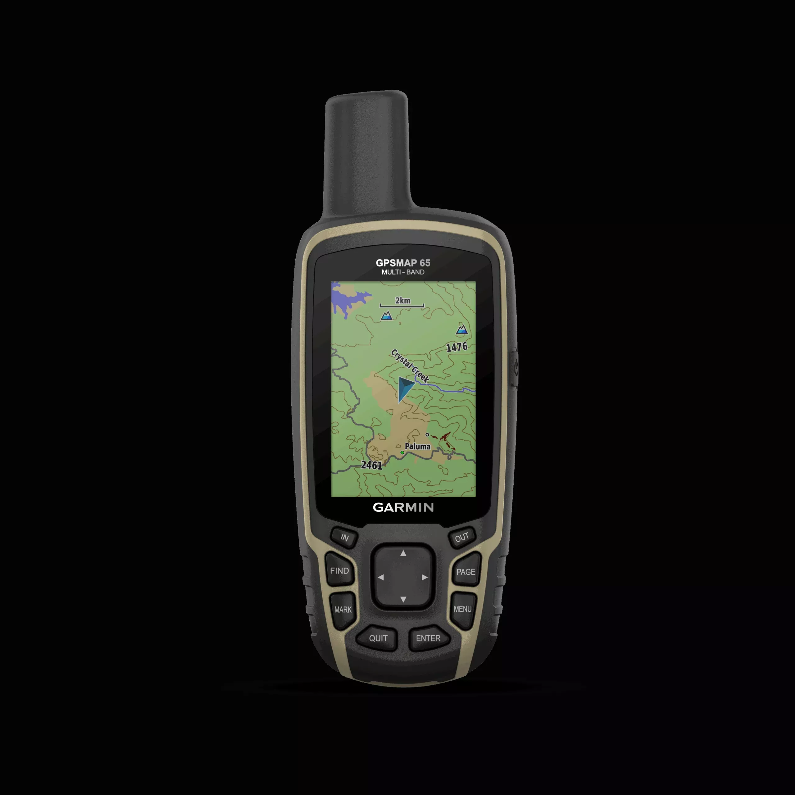
Explore more with this rugged handheld that offers optimal tracking accuracy, a 2.6″ color display, and preloaded maps.
Don’t miss a single detail with this large sunlight-readable color display.
Show the way in challenging locations thanks to multi-band technology and expanded GNSS satellite support.
Walk off-road with TopoActive maps of Europe with route definition capabilities.
Embark on an adventure without fear. This rugged handheld device is designed for demanding environments.
Organize your adventure from anywhere with the Garmin Explore™ app and website1.
Travel with up to 16 hours of battery life in GPS mode.
Go on your way.
Expanded GNSS Support
Multi-band technology and extended GNSS support (GPS, GLONASS, Galileo, QZSS, and IRNSS) provide optimal accuracy in rugged terrain, urban canyons, and lush forests.
PRE-INSTALLED Topoactive Maps of Europe
Preloaded TopoActive maps of Europe provide detailed views of street and off-road networks with routes, waterways, natural features, terrain layout, buildings, and more.
Smart Notifications
Receive emails, texts, and alerts directly on your handheld when paired with a compatible device.
Garmin Explore App
Plan, review and sync waypoints, routes and tracks with the Garmin Explore website and app. You can even review activities completed in the field.
Microsd™ Slot
Use your compatible device and a microSD memory card to conveniently download the TOPO 24K maps and get going, or access HuntView Plus maps to view public land types and boundaries, as well as the names of private landowners and their boundaries.
Geocaching
Get automatic Geocaching Live cache updates, with descriptions, logs, and suggestions.
Specifications:
| Lens Material | chemically strengthened glass |
| Unit Dimensions (Width/Height/Depth) | 6.1 X 16.0 X 3.6 cm |
| Weight | 217 g with batteries |
| Water resistance rating | IPX7 |
| Display Type | 65,000 color transflective TFT |
| Screen Size (Width/Height) | 3.6 x 5.5 cm; 2.6 inches diagonally (6.6 cm) |
| Screen Resolution (Width/Height) | 160 X 240 pixels |
| Battery | 2 x AA batteries (not included); NiMH or lithium is recommended |
| Battery life | 16 hours |
| Memory/History | 16 GB (user space varies depending on included maps) |
| Interface | Compatible with high-speed mini-USB and NMEA 0183 |
| Maps and memory | |
|---|---|
| Preloaded maps | Yes (TopoActive Europe; with routing function) |
| Ability to add maps | Yes |
| Basemap | Yes |
| Automatic route creation (turn by turn on the road) | Yes |
| Map segments | 3000 |
| BirdsEye | 250 BirdsEye image files |
| Includes highly detailed hydrographic features (shorelines, shorelines of lakes and rivers, swamps, and perennial and seasonal streams) | Yes |
| Includes searches for points of interest (parks, campgrounds, picturesque watchtowers, and picnic areas) | Yes |
| It shows national, regional and local parks, forests and natural landscapes | Yes |
| Storage and Load Capacity | Yes (32GB microSD™ card maximum) |
| Waypoints | 5000 |
| Tracks | 200 |
| Tracks | 10,000 points, 200 tracks Saved |
| Routes | 200, 250 points per route; 50 automatic route points |
| Sensors | |
|---|---|
| GPS | Yes |
| Glonass | Yes |
| Galileo | Yes |
| QZSS | Yes |
| High Sensitivity Receiver | Yes |
| GPS compass (moving) | Yes |
| Multi-band frequency | Yes |
| Everyday smart features | |
|---|---|
| Smart notifications on your handheld device | Yes |
| Remote control for VIRB® | Yes |
| Compatible with Garmin Connect™ Mobile | Yes |
| Outdoor Leisure Features | |
|---|---|
| Point-to-Point Navigation | Yes |
| Area Calculation | Yes |
| Fishing forecast | Yes |
| Astronomical information | Yes |
| Modo geocaching | Yes (paperless) |
| Supports custom maps | Yes (500 custom map tiles) |
| Image Viewer | Yes |
| Outdoor Applications | |
|---|---|
| Compatible with Garmin Explore™ for waypoints, tracks, routes and activities | Yes |
| Compatible with the Garmin Explore website | Yes |
| Connections | |
|---|---|
| Wireless connectivity | Yes – Bluetooth, ANT+ |
In the box:
- Gpsmap 65
- Cable USB
- Carabiner clip
- Documentation
FAQs
Repairs should only be made by an authorized Garmin service center to maintain warranty and avoid permanent equipment damage.
The product does not contain user-serviceable parts. Unauthorized repairs or modifications void warranty and may cause damage.
Information about the Garmin product recycling program and WEEE, RoHS, REACH, and other compliance programs is available.
Yes, Garmin declares that this product is in compliance with Directive 2014/53/EU.
Yes. This device complies with part 15 of the FCC Rules.
Try to correct the interference by reorienting the antenna, increasing separation, or consulting a technician.
Contact the SailRACE team — as certified marine experts we’re happy to help with product selection, installation and after-sales servicing, before and after your purchase.